How Waterfront Living Shapes Your Green Bay Home Search
March 5, 2026
March 5, 2026
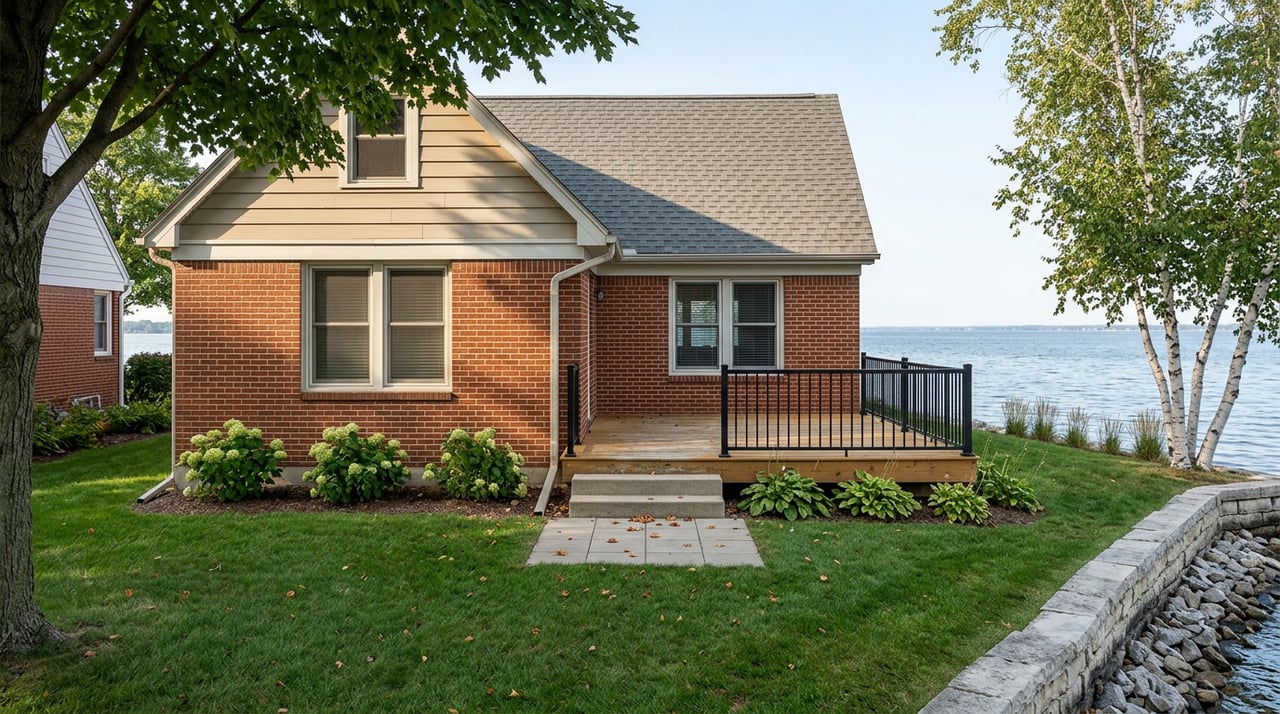
Does your dream home include sunrise over the bay or a quiet evening on the dock? If you are eyeing Green Bay or the Lower Fox River, water changes almost every part of your home search. You will weigh shoreline rights, docks and permits, flood maps, winter care, and long-term costs in a different way than a typical purchase. This guide gives you a clear path so you can compare options with confidence and avoid costly surprises. Let’s dive in.
Not all “waterfront” is the same. You will see four common setups in Green Bay and Brown County:
Before you offer, confirm what the listing conveys. Check shoreline frontage width, easements, and any recorded restrictions so you know your rights and limits.
Waterfront living in Green Bay is as much about lifestyle as it is about the house. Think through:
Waterfront typically carries a premium over similar non-water homes, but the size of that premium is highly local. National research shows wide variation, which is why you should rely on up-to-date local comps for Green Bay neighborhoods. For context on how variable premiums can be, see this overview of waterfront pricing differences, then pair it with current local sales before you set your budget.
The OHWM is a legal and field determination used to separate private upland from state waters. Activities below the OHWM, like piers, dredging, or placing rock, generally need state review. Work above the OHWM is handled by local shoreland zoning. Ask for any DNR OHWM determinations or a recent survey that shows the OHWM and structures. Start with the DNR’s guide to the Ordinary High Water Mark.
One of the most common questions is, “Can I have a pier and how large?” Wisconsin sets standards for size and use, and many legacy piers placed before April 17, 2012 are grandfathered. New piers must meet the DNR’s Pier Planner standards or obtain permits. An existing dock you see is not proof of compliance. Request permits, registrations, and any DNR correspondence. The DNR summarizes exemptions, general permits, and individual permits on its Waterways recreation and permitting page.
Seawalls usually require individual DNR permits and are discouraged where other solutions work. Rock riprap and vegetative, bioengineered approaches are often preferred and may qualify for exemptions in some cases. On top of state rules, local shoreland zoning controls setbacks, impervious-surface limits, and clearing standards. Check both state and local rules before planning work. For state program guidance, read the DNR’s permit FAQs. For county contacts, parcel info, and local ordinances, use the Brown County website.
Projects that affect navigable waters or wetlands can also need U.S. Army Corps of Engineers and Clean Water Act approvals. Ask whether past or planned shoreline work required federal review. The DNR’s Waterways page outlines common permit pathways and timelines.
Green Bay water levels, tied to the Lake Michigan–Huron system, rise and fall across seasons and years. These swings affect dock function and shoreline erosion. Plan for variability. Floating docks or adjustable ramps can help, and siting new structures without an OHWM check is risky. For a good snapshot of recent water-level context and coastal risk, see the Wisconsin Coastal Resilience update.
Flood zones influence lending, building options, and insurance cost. Look up each address in the FEMA Flood Map Service Center and ask your lender and insurer for quotes early. The National Flood Insurance Program now prices risk with more property-specific factors, so premiums can vary with elevation, location, and construction. If needed, request an elevation certificate to refine quotes and lending requirements.
The Lower Fox River and parts of Green Bay are a Great Lakes Area of Concern due to historic PCB contamination, with long-term cleanup and monitoring in place. This history can affect fish consumption guidance and public perception. For context on the cleanup, review the EPA and DNR background in this overview of the Lower Fox River project. For current, species-specific advisories, refer to the state’s fishing regulations and health guidance.
Ice movement and freeze–thaw cycles are a fact of life. Many owners remove docks seasonally or use floating systems designed for winter conditions. Plan your boating season for warmer months and consider safe ice use only when conditions allow. The DNR’s Waterways page covers seasonal practices and permitting for structures.
Convenience on the water comes down to slip availability, pier size limits, and proximity to launches. Explore local clubs and marinas like the Green Bay Yacht Club, and map out public ramps and travel times to open water if you plan to cruise. Also remember that Green Bay is a working port. Visit candidate properties when ships and commercial traffic are active to assess wakes, noise, and activity. For harbor and county information, start at the Brown County website.
Waterfront homes often carry extra upkeep. Plan for:
Costs vary with design, exposure, and contractor availability. If you anticipate shoreline work, the DNR’s permit FAQs outline what may trigger permits and how timelines work.
Standard homeowners insurance does not cover flood. If a property sits in a Special Flood Hazard Area, lenders usually require flood insurance. Get quotes early, review FEMA maps, and budget for premiums. Lenders may also ask for elevation data and documentation that clarifies OHWM location and shoreline improvements. You can start with the FEMA Map Service Center and the DNR guide to the OHWM.
Use this quick check to narrow your search:
Before you write an offer, gather these items or make them contingencies:
Winters in Green Bay shape how you use and protect your waterfront. Most owners remove fixed docks or switch to floating systems with ice-ready hardware. Schedule professional removal and spring reinstall to avoid damage. Keep shore protection clear of large debris after storms, inspect riprap or seawalls annually, and confirm that any repairs fit state and local rules. If you plan improvements, review the DNR’s permitting resources early so you can align designs with what is likely to be approved.
Waterfront living in Green Bay offers a rare mix of access, views, and outdoor fun. The best experiences start with clear knowledge of shoreline rights, permits, flood maps, seasonal realities, and costs. With a smart plan and the right due diligence, you can enjoy the water while protecting your investment for years to come.
If you want tailored guidance on bayfront or riverfront homes, connect with the Becky Buckland Collaborative for a personalized consultation and a search strategy that fits how you live.
Stay up to date on the latest real estate trends.


Whether you’re ready to buy, sell, or invest, Becky Buckland Real Estate Collaborative is here to make the process smooth and successful. Put our local expertise and dedication to work for you.
